2021 Nov - The Great Loop: Flying Gold After Crossing Our Wake in Fort Myers!
- Lisa
- Dec 6, 2021
- 9 min read

Great Loop Overall Statistics to date:
Statute Miles: 5946.2
Average Miles/Day: 51.3
Total Hours Underway: 787.8
Average speed (mph): 7.6
States Transited: 19
Total Days: 251
Travel Days: 114
Locks: 75
Fuel Purchased: 1698.3
Miles / Gallon: 3.5
Nights at Extra Days
Marinas: 65 123
Anchor: 37 8
City dock: 6 1
Free Wall: 9 4
Mooring: 0 0
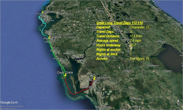
Travel Day 112 Leaving Clearwater
We left Clearwater at slack current in order to have an easier time getting out of the crowded marina. Behind us was a large boat whose bow pulpit and anchor were well into the fairway that we wanted to back into before coming about to leave. Luckily there was no wind or current, and with a bit of the bow pulpit/anchor protruding into our cockpit as we slid back, we were able to rotate the boat and get away. The rest of the day was quite uneventful and we had an easy time across Tampa Bay and down into the Sarasota area.
Travel Day 113 Leaving Sarasota
We headed south early to get to Cayo Costa as soon as possible. Our target was an anchorage at Punta Blanca that basically only had room for 1 boat. We wanted to get there ahead of anyone arriving that afternoon. Well, it was all for naught. There was someone in the anchorage already. Instead of going back outside to the channel (see chart), we took a chance with the skinny water to move up to the main anchorage at Pelican Bay. We would not do that again – following the sonar charts (which were accurate, BTW) to a ‘T’, we still saw less than 4ft of water in some spots with the tide at the time. Moving very, VERY slowly, we made our way up to the main anchorage and settled in. There were not too many boats because it was still mid-week.
Travel Day 114 Leaving Cayo Costa
We left Cayo Costa a mid-tide and no wind and eased out the northern channel of Pelican Bay with no problems. The water was 6ft or more all the way back out to the main channel outside. Another low-wind/wave day down to Fort Myers where we topped off the fuel tanks (114 gal) to measure our total consumption for the Great Loop. We then moved 1/4 mile over to Legacy Harbor marina and SQUEEZED into a narrow (for us) slip that they had graciously provided us, knowing that we were crossing our wake where we had left 8-1/2 months earlier. We took some photos with our newly-hoisted gold flag!
----
Great Loop Travel Days (GLTD):
112: Sarasota FL from Clearwater FL
113: Cayo Costa FL from Sarasota FL
114: Fort Myers FL from Cayo Costa FL
Map of our Overall Great Loop travel:
GLTD112 Sarasota FL (from Clearwater FL): Ray carefully maneuvered us out of a tight fit. The 65-foot boat in the 45-foot slip behind us overhung the fairway by 20 feet. 😒 Thankfully, there was almost no current, and only 3-5 mph wind.
We were underway by 6:30 am with our red Christmas bows on the bow rail!

Ray donned his lifejacket and climbed up top to lower the antennas for low bridges on today's route.
There are some large waterfront estates in this area of Florida.

Most of the morning, it was pretty smooth sailing, with low boat traffic (i.e. not too many wakes to worry about).
We didn’t spot too many birds at Tarpon Key Bird Sanctuary, part of Pinellas National Wildlife Refuge, which was established in 1951 as a breeding ground for colonial bird species. Herons, cormorants, egrets, endangered brown pelicans and many more species use this quiet refuge for nesting. Tarpon key, one of the islands making-up the refuge, hosts the largest brown pelican rookery in the state of Florida. The abundant green sea grass beds around the island are protected from motorized boat activity.

Just before lunch, we passed Sunshine Skyway Bridge across Tampa Bay. It was a beautiful day for cruising!

After lunch, I was intrigued by this stilt home, “Guthrie Net Camp”, near Cortez FL. With a little research, I learned the building is in a legal battle for survival.
🌎 Small World - Carolina Connection: The building has ties to North Carolina. For more than a century, the people of Cortez have made a living harvesting seafood from Sarasota Bay. In the 1880s, the area was settled by five fishermen from Carteret County North Carolina […]
The life of the fisherman was not an easy one. The men used “skipjacks,” or small sailing vessels. Back then, nets were made of cotton and had to be dried. Fishing during the prime seasons required long hours. The men built stilt houses off the coast where they could dock their boats, get a few hours of sleep, and dry their nets on apparatuses called ‘net spreads’ so they could be ready to go as soon as the sun came up.
Ref: Carolina Connection: https://thebradentontimes.com/sunday-favorites-net-spreads-and-stilt-houses-p22639-133.htm

Almost directly across the bay from the net camp, is a popular floating jungle gym. This looks fun!

As we approached Sarasota, boat traffic -- more importantly, wakes -- increased. But there was no swell "inside” the barrier islands, so all was well. 😊
The closer we got to Sarasota, however, the bigger the boats, and .... you guessed it – bigger wakes!

By late afternoon, we were docked at Marina Jack Yacht Basin. The marina has easy-entry transient slips with a roomy basin, 3 sets of coin laundry machines, in-slip pump-out, a large mooring field, and on-site restaurant with live music most nights. There is a Whole Foods just 1/2 mile away.
I checked in while Ray secured SCOUT and connected the power. We each freshened up and walked to the onsite restaurant patio for an “all-secure” beverage.

Friends ”giving” Reunion: We had made plans, while under way, to have dinner with friends and former Great Harbour owners of mv Seven Tenths.

They arrived at the marina, bearing “gifts” – they brought some parts we ordered from our boat manufacturer, Mirage.
It was great to see them again! We had not seen them since March -- just be we started the loop in Fort Myers (this photo).

Not to Miss: Food: Cask Ale Kitchen had a good selection of beer, wine, and cocktails, and we all cleaned our plates!
Some of us enjoyed the special cocktail, Gingerbread Old Fashioned. Yum!

I had to include this photo of mv Seven Tenths walking through downtown, because I just noticed that awesome Seven Tenths jacket!
The next day, between breakfast and dinner out, we pumped out the holding tank, and I did some laundry while Ray made a small provisioning run at the nearby Whole Foods.
We got a close look at the sculpture Unconditional Surrender – right beside the marina, commemorating the well-recognized image of the sailor and nurse celebrating the end of World War II.

The gulf sunset was beautiful beyond the park across the marina basin. THIS is Florida! 😊

Missed Opportunities: With a short stay and chores to do, we didn’t have time for sightseeing. We may need to make a return trip to see Ringling Brothers Museum and Marie Selby Botanical Gardens.
GLTD113 Cayo Costa FL (from Sarasota FL): We left the marina before 7:00 -- just as the sun was rising.


Wonderful Weather!
Ray had been watching the weather forecast for the last week, and we were in for a gorgeous few days at anchor!
Tickled Pink! I was excited when Ray spotted these Roseate Spoonbills! I love these elusive birds.

Hazard to Navigation: Before passing under Stickney Point Bridge, a sculler decided to “share” the channel with us -- and stayed with us as we passed under the center of the bridge (where SCOUT must travel for the mast to fit under). 🤔That's a little risky. The only reason we thought he may be IN the channel was to gain the current.

We passed 2 Great Harbours today! -- future mv SloMo (N37) and mv Selkie (TT35). Hi guys!

Mid-morning, we "strolled" through Venice. It’s a very pretty area, with mainland homes nestled among the mangroves. I would love to be the lucky owner of this awesome banyan tree!

Venetian Waterway Park is home to 1927 Historic Venice Train Depot, and a trail that runs along both sides of the canal that connects Venice FL and South Venice FL. The Venice Area Historical Society acquired a train car, just this year, that was used during winters by Ringling Bros. and Barnum & Bailey Circus. After it is restored, it will be opened to the public. The water in the canal was like a mirror!

The areas south of Venice have beautiful blue-green water, tons of mangroves, and lush barrier islands!

Did I mention the gorgeous the water? This looks like the Florida Keys!

Lunch Time: While having lunch, we passed this osprey -- also having lunch.

I’m calling this island Pelican Point. Wow! 😮 …and it wasn’t even the weekend!

I can’t even begin to guess how many pelicans are sharing that spit of land.

A few dolphins played in our wake along the way. One of these dolphins has a curly fin.
Click for short video:
We crossed Charlotte Harbor early afternoon. It was like glass! Gorgeous waters.

We planned to anchor at the remote, room-for-1-boat, Punta Blanca Island anchorage in Cayo Costa. These piling ruins gave Ray a little pause as he navigated through the “skinny” (shallow) entrance.

The water is so clear, I could see all the way down to the bottom as we entered.

⚓Anchored. Bummer! Another boat was already anchored there, so we slowly made our way around to anchor in the “general admission” area, Pelican Bay. We would stay here for 3 nights.

“Gullfriend”: It seemed like I made a connection with this cute sea gull. Ray read that they hang around the boats anchored here because some people feed them. I did not feed this gull, but boy….she was patient and persistent … and cute! Bless her heart! 💛

We saw a nice sunset …

… before it was dark enough for our Christmas lights to come on 😊🎄

Sunrise. We saw the sun rise -- just as the moon was setting. I was curious what caused those blue rays on the horizon. Those are crepuscular rays, probably caused by small clouds in the distance, blocking the sun’s light. Ref: https://earthsky.org/earth/how-to-see-anticrepuscular-rays/

Dinghy-to-Beach: Ray lowered the dinghy (from atop the deckhouse) while I packed a small backpack cooler with snacks. We beached the dinghy near the state park docks and walked 0.7 miles through the hammock to the beach on the west side of the island.

There were several small groups of people on the beach, presumably from the ferry that runs from Pineland FL. We enjoyed the warm breeze and walked the beach looking at (for) shells.

Sunset from the front “porch”.

Dinghy-to-Cabbage Key: We dinghied 2 miles (one way) for lunch at Cabbage Key, one of many places in Florida rumored to be the inspiration for Jimmy Buffett’s “Cheeseburger In Paradise”. Here’s Ray in our little dinghy, where we beached by the mangroves while we had lunch.

Cheeseburgers in paradise, nestled among the palm coconut trees.
Hmm…no pickle or French fried potatoes. 🤔

History: Cabbage Key is an ice age sand dune. An extensive Calusa Indian shell midden is located on Cabbage Key. The Calusa Indians were known to have lived in the Pineland area for about 2000 years until the mid-1700's.
We walked to the top of the 60-feet high water tower for the photo below. The tower was built in the 1930’s and is the last original water tower in this area that is still standing. Others were destroyed by hurricanes.

Interesting Fact: An 1875 survey of the region used the name ‘Palmetto Key’ to identify the island. This early plat map showed two islands, 'Palmetto Key' and 'Cabbage Key', but they were actually the same island, put on the map twice, at different locations. That mistake, in time, would cause a legal dispute over ownership that would eventually be settled by the U.S. Supreme Court.
Celebrities: In the 1920’s & 30’s, America’s bestselling mystery writer was Mary Roberts Rinehart. Her play, The Bat (1920) […] was Bob Kane's inspiration for Batman. Ernest Hemingway, Katharine Hepburn, Ted Koppel, Jimmy Buffett, Ed McMahon, Rob Lowe, and Julia Roberts have all bent an elbow here. Cabbage Key has always treated everyone the same and doesn't make a fuss over celebrities. Ref: https://cabbagekey.com/history/
Clear Glassy Water: The ride back to SCOUT in Pelican Bay was like gliding through a bathtub – clear, silky water.

Ray was in his happy place – well, one of his happy places. 😊

GLTD113 Fort Myers FL (from Cayo Costa FL): Ray hauled anchor at 7:00, as the sun was rising.

Seas were flat, despite a 10-mph wind. We saw several dolphins in Charlotte Harbor, but they didn't want to play in our wake. 🙁
Cabbage Key harbor was desolate, compared with the crowd at lunch the day before.

From a distance, we couldn’t tell how all these “sticks” were travelling. The sailboat fleet was under tow. They looked to be a bunch derelict boats being towed somewhere by the lead sailboat.

This is just a few of the fleet of kayaks we saw as we passed Cape Coral.

We enjoyed the pleasant short cruise. By a little after noon, we were fueling up at Fort Myers Yacht Basin.
And 1/2 hour later, we were docked at Legacy Harbor Marina, where we celebrated the end of our Great Loop by raising the gold flag!
We are Gold Loopers!

What’s next? In our blog next week, we will share some of our Great Loop statistics, as well as highlight some of our favorite ports, anchorages, meals, and breweries!
Click here to view our previous blog posts: https://n37scout.wixsite.com/travels/blog


Comments